RGI glacier regions#
RGI outlines are organized into 20 first-order glacier regions. This is one more than in RGI 6.0 and earlier versions, since former region 19 was split into two regions (global map; Table 1a). These are further subdivided into second-order regions, of which there are 90 in total in RGI 7.0 (Table 1b). Glacier regions are useful for regional assessments of glacier change and other variables.
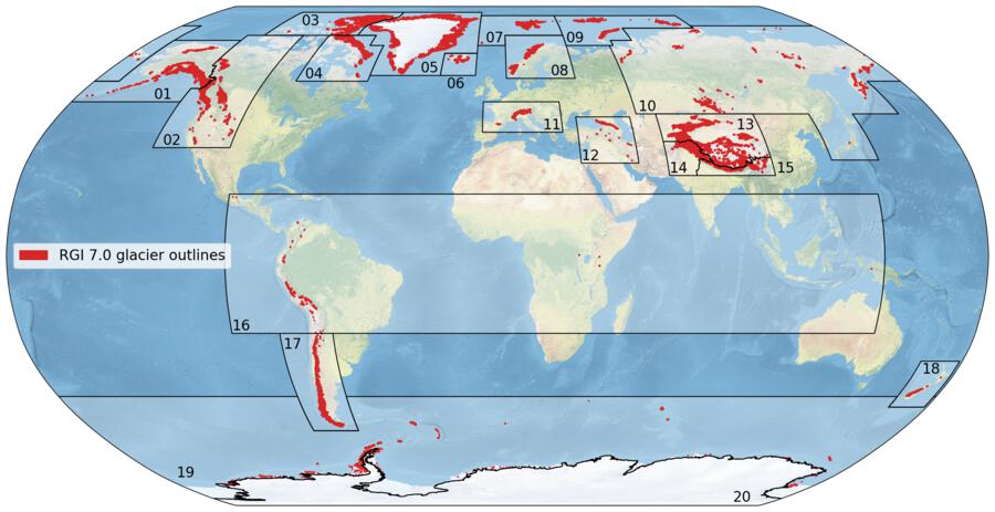
Fig. 1 First-order regions of the RGI version 7.0 and glacier locations in red.
Download high resolution version.#
Data download
First-order regions 10, 19 and 20 straddle the 180th meridian, and so do the second-order regions 19-15 and 20-01. For convenience of analysis in a cylindrical-equidistant coordinate system centered on longitude 0°, as in Figure 1, the region outlines of 10 and 19-15 appear in the accompanying shapefiles as two polygons, eastern and western.
GTN-G regions
The region outlines have changed slightly between RGI versions, for example to avoid the splitting of glaciers between two regions, to make further analyses more convenient, or because previously not included glaciers were located outside existing region boundaries. For the sake of consistency between global glacier datasets a joint set of regions was recommended by the Global Terrestrial Network for Glaciers (GTN-G) Advisory Board, the Global Land Ice Measurements from Space initiative (GLIMS), the RGI Working Group of the International Association of Cryospheric Sciences (IACS), and the World Glacier Monitoring Service (WGMS). These glacier regions were implemented first in RGI version 6.0 and are available on the GTN-G website. These region boundaries were slightly modified in RGI version 7.0 and changes also integrated in the GTN-G dataset [GTN-G, 2023].
Changes from RGI 6.0 to 7.0#
Region boundary and name changes
The region boxes for region
01(Alaska) used to encompass some islands in the Bering Sea East of Kamtchatka. One of the two boxes, part of subregion01-03Alaska Peninsula (Aleutians), contains no glaciers (and probably hasn’t for a long time) and is now removed.Subregion
05-11(Greenland Ice Sheet) was removed since it was coarsely defined and the RGI does not include the ice sheet proper.The southern boundary of region
12(Caucasus and Middle East) was shifted south by 2° (from 32°N to 30°N) to encompass a cluster of glaciers which were previously not included.Region
19(“Antarctic and Subantarctic”) was split into two first-order regions. Region19now solely includes the islands in the periphery of Antarctica, and was renamed to “Subantarctic and Antarctic Islands”. A new region20, (“Antarctic Mainland”) was added to encompass the remaining subregion (“Antarctic Ice Sheet”, previously19-31and now20-01), but it presently contains no glaciers in the RGI (nor has the corresponding former subregion19-31in all previous RGI versions).Region names in the region shapefiles (and therefore of the associated RGI product files) were harmonized to reflect the most commonly used version in various documents and publications of the RGI. “Arctic Canada, North” and “Arctic Canada, South” have been renamed “Arctic Canada North” and “Arctic Canada South” (comma removed), respectively. The four regions in Asia (“North”, “Central”, “South West” and “South East”) were renamed to “North Asia”, “Central Asia”, “South Asia West” and “South Asia East”, respectively. With this change, none of the regions and subregions in RGI 7.0 have a comma in their name.
Technical changes
The data type of the
rgi_codeattribute in the first-order region file is nowstr(instead ofint). Thergi_codenow has a leading zero, for example02instead of2.All abbreviations in the second-order regions file have been replaced by their full name (e.g. “East Central” instead of “EC”)
The first-order and second-order region files now have a field called
long_codewhich contains a string representing the full region name, using the lowercase with underscores format (e.g.02_western_canada_usa). This field is used to name the corresponding RGI shapefiles.The
WGMS_CODEcolumn was deleted from all files.The
RGI_CODEcolumn is now calledo1region(first order files) ando2region(second-order files).
Additional details: RGI regions version history
In RGI 6.0, the eastern boundaries of regions 13 (Central Asia) and 15 (South Asia East) were extended slightly to the east. A new second-order region 10-07 covering Japan was added to region 10 (North Asia). Region 08-01 (S Norway) was subdivided into regions 08-02 (SW Scandinavia) and 08-03 (SE Scandinavia), with former region 08-02 (N Scandinavia) assuming the code 08-01. Region 02-01 (Melville Island) was transferred to first-order region 03 (Arctic Canada North) as region 03-07, and the other second-order regions of region 02 (Western Canada and US) were renumbered as 02-01 to 02-05. These changes ensure the compatibility of the Glacier Regions dataset of the Global Terrestrial Network for Glaciers (GTN-G) with the RGI regions.
In RGI 5.0, the boundary between regions 01 (Alaska) and 02 (Western Canada and US) was refined, and in region 10 (North Asia) the former four second-order regions became six regions conforming with those described by Earl and Gardner (2016). In RGI 4.0, region 10-01, North Asia (North), was extended slightly to the west for better visibility of glaciers in the Polar Urals. Region 11-02, formerly the Pyrenees and Apennines, was enlarged and renamed Southern and Eastern Europe. First-order regions 10 (North Asia) and 11 (Central Europe) were enlarged accordingly.