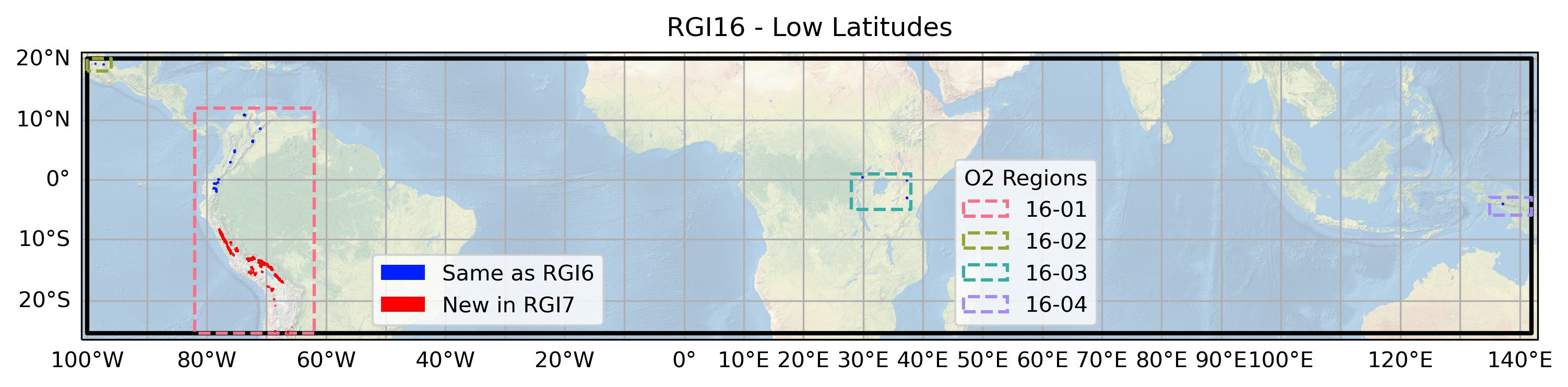
16: Low Latitudes#
The region encompasses all glaciers in the tropics and sub-tropics (25°S-20°N) including glaciers in South America, Africa and Indonesia.
Subregions
16-01: Low-latitude Andes
16-02: Mexico
16-03: East Africa
16-04: New Guinea

Fig. 69 Regional glacier area. Download high resolution version.#
Changes from version 6.0 to 7.0#
Peru and Bolivia
All RGI 6.0 outlines were replaced since they had been derived from satellite images with adverse snow conditions acquired over a 10-year period. Many outlines assumed a triangular shape during raster-vector conversion, and had ice divides in the wrong place. The outlines in RGI 7.0 are based on 17 Landsat 5 TM scenes that were acquired in 1998 with excellent snow conditions for mapping. Outlines for clean glaciers were created from a simple red/SWIR band ratio with scene specific thresholds. After raster-vector conversion, wrongly mapped lakes were removed and missing debris-cover was manually added. New ice divides were derived from the 30 m resolution Copernicus DEM using the divides in RGI 6.0 as a base. The interpretation was supported by glacier outlines from the national glacier inventory of Peru and the “World imagery” layer of the ESRI basemap.
Chile and Argentina
Some glaciers in northern Chile and Argentina were replaced. Details are given in 17: Southern Andes.
Additional information#
Data sources and analysts
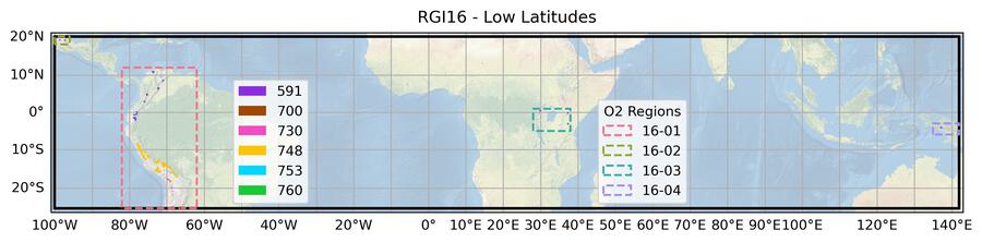
Fig. 70 Submission IDs used for this region Download high resolution version.#
Glacier outline providers to GLIMS
This list includes the providers of the outlines used in the RGI 7.0 as generated automatically from the GLIMS outlines metadata. We acknowledge that the list may be incomplete due to omissions in the GLIMS database.
- Submission 591
Submitter: Cogley, Graham.
Number of outlines: 158. Area: 169.2km². Release date: 2015-07-16.
Analysts: Kienholz, Christian; Miles, Evan; Sharp, Martin; Wyatt, F..- Submission 700
Submitter: Hidalgo, Lidia Ferri.
Number of outlines: 17. Area: 1.5km². Release date: 2018-09-04.
Analysts: Castro, Mariano; Gargantini, Hernán; Gimenez, Melisa; Hidalgo, Lidia Ferri; Masiokas, Mariano; Pecker Marcosig, Ivanna; Pitte, Pierre; Ruiz, Lucas; Zalazar, Laura.- Submission 730
Submitter: Barcaza, Gonzalo.
Number of outlines: 20. Area: 9.4km². Release date: 2018-07-24.
Analysts: Albornoz, Amapola; Arias, Victor; Barcaza, Gonzalo; Garcia, Juan-Luis; Nussbaumer, Samuel; Tapia, Guillermo; Valdes, Javier; Videla, Yohan.- Submission 748
Submitter: Paul, Frank.
Number of outlines: 3495. Area: 1734.7km². Release date: 2021-09-02.
Analysts: Goerlich, Franz; Paul, Frank; Rastner, Philipp.- Submission 753
Submitter: Maussion, Fabien.
Number of outlines: 4. Area: 13.6km². Release date: 2022-04-18.
Analysts: Cáceres, B.; Francou, B.; Jordan, S.; Peñafiel, A.; Ungerechts, L..- Submission 760
Submitter: Maussion, Fabien.
Number of outlines: 1. Area: 0.1km². Release date: 2022-04-19.
Analysts: Kienholz, Christian; Miles, Evan; Sharp, Martin; Wyatt, F..- Reviewers
Prinz, Rainer; Rabatel, Antoine;
Regional statistics
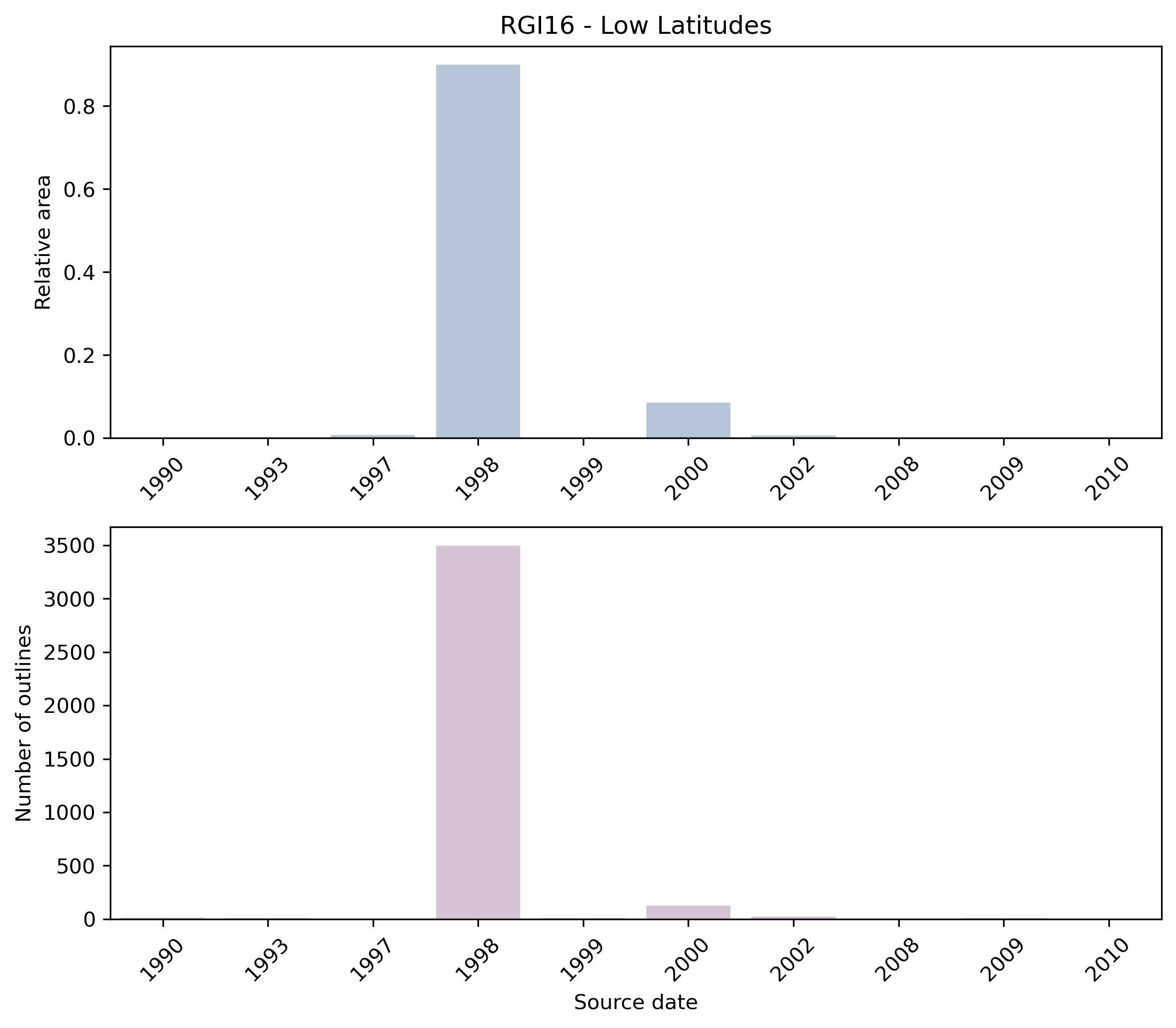
Fig. 71 Distribution of the outline dates per area (top) and number (bottom)#
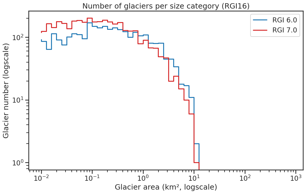
Fig. 72 Number of glaciers per size category (log-log scale).#
Regional number of glaciers (N) and area (km²) per terminus type in RGI 7.0 and RGI 6.0. Note that the default designation in RGI 7.0 is now “Not assigned”, while in RGI 6.0 lake-terminating glaciers and shelf-terminating glaciers were identified in some regions. The RGI region 19 is entirely labelled as “Not assigned” in RGI 7.0.
Value |
Terminus type |
RGI 7.0 (N) |
RGI 6.0 (N) |
RGI 7.0 (Area) |
RGI 6.0 (Area) |
|---|---|---|---|---|---|
0 |
Land-terminating |
0 |
2939 |
0 |
2341 |
1 |
Marine-terminating |
0 |
0 |
0 |
0 |
2 |
Lake-terminating |
0 |
0 |
0 |
0 |
3 |
Shelf-terminating |
0 |
0 |
0 |
0 |
9 |
Not assigned |
3695 |
0 |
1929 |
0 |
Regional number of glaciers (N) and area (km²) per surge type attribute in RGI 7.0 and RGI 6.0.
Value |
Surge type |
RGI 7.0 (N) |
RGI 6.0 (N) |
RGI 7.0 (Area) |
RGI 6.0 (Area) |
|---|---|---|---|---|---|
0 |
No evidence |
3695 |
48 |
1929 |
8 |
1 |
Possible |
0 |
0 |
0 |
0 |
2 |
Probable |
0 |
0 |
0 |
0 |
3 |
Observed |
0 |
0 |
0 |
0 |
9 |
Not assigned |
0 |
2891 |
0 |
2333 |
Version history
- Changes from Version 5.0 to 6.0
Coverage of the glaciers of Cotopaxi, Ecuador, was replaced with outlines for 1997 digitized from Jordan et al. [2005]).
- Changes from Version 4.0 to 5.0
Links were added to 2 glaciers in the WGMS mass-balance database.
- Changes from Version 3.2 to 4.0
94 exterior GLIMSIds were replaced. Topographic and hypsometric attributes were added.
The 81 remaining glacier complexes in the Bolivian Andes were subdivided by C. Kienholz into 159 glaciers. RGIIds for the whole of region 16 were altered in consequence.- Changes from Version 3.0 to 3.2
Outlines of the glaciers of Mexico were replaced with outlines provided by E. Burgess, and the nominal glaciers of east Africa and New Guinea were replaced with outlines provided by N.J. Cullen and A. Klein respectively. Note that several glacier complexes are still present in southern Peru and western Bolivia.
- Changes from Version 2.0 to Version 3.0
Some outlines in northern Chile were improved.
- Changes from Version 1.0 to Version 2.0
Outlines of the glaciers of Mexico (16-02) were digitized by J.G. Cogley from maps in “Satellite Image Atlas of Glaciers of the World – North America”. 59 glaciers in east Africa (16-03) and seven in New Guinea (16-04) were added as nominal circles from WGI-XF.
See the RGI v6 Technical Note for an extended summary of quality controls conducted by E.S. Miles, University of British Columbia.- Version 1.0
Shapefiles were created from late-summer, cloud-free Landsat 7 ETM+ imagery acquired prior to the 2003 scan line corrector (SLC) failure. To identify glacier surfaces, a normalized difference snow index (NDSI) was calculated using bands 5 and 2 for the red and near-infrared bands respectively. A threshold of approximately 0.5-0.65 was used to identify dirty/shady/bare ice, and one from 0.65-0.99 to identify snow-covered ice. Gridded files were then converted to polygons and additional manual editing was carried out to eliminate incorrectly classified regions.