05: Greenland Periphery#
The region encompasses all glaciers not connected or only weakly connected to the ice sheet as defined by connectivity levels 0 and 1 in [Rastner et al., 2012].
Subregions
05-01: Greenland Periphery
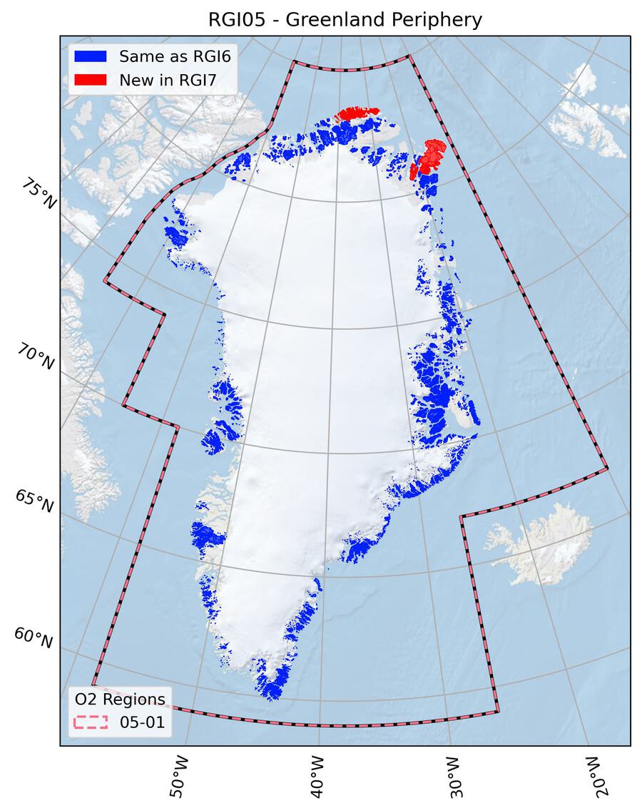
Fig. 25 Regional glacier area. Download high resolution version.#
Changes from version 6.0 to 7.0#
Northernmost tip of Greenland
RGI 6.0 glacier outlines in the very north of Greenland suffered from low quality due to their location outside the Landsat field of view. Therefore glaciers in two areas in the very north of Greenland were replaced by new outlines derived from orthoimages from 1978 provided by Korsgaard et al. [2016] and hillshade representations of the ArcticDEM. Some seasonal snow complicated outline detection at higher elevations; thus some overestimation of glacier area is likely. ASTER scenes closer to the target year (2000) were not considered since these are affected by clouds or seasonal snow, however, it was assumed that glacier area changes in this region between 1978 and 2000 are relatively small.
Flade Isblink Icecap
The Flade Isblink Icecap was not fully subdivided into individual glaciers in RGI 6.0. This was rectified in RGI 7.0 by adding ice divides.
Other changes
Glaciers with connectivity level 2 [Rastner et al., 2012] have been removed entirely from the RGI 7.0, since they are typically not included in mass change assessments or projections of glaciers outside the ice sheet. This change removes a source of confusion when differentiating between glaciers and the ice sheet proper. See the “Version history” section below for a description of the connectivity levels and why they were included in previous versions.
Additional information#
Data sources and analysts
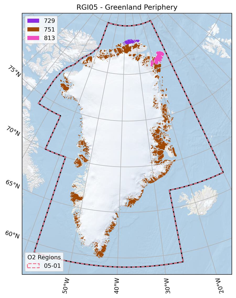
Fig. 26 Submission IDs used for this region Download high resolution version.#
Glacier outline providers to GLIMS
This list includes the providers of the outlines used in the RGI 7.0 as generated automatically from the GLIMS outlines metadata. We acknowledge that the list may be incomplete due to omissions in the GLIMS database.
- Submission 729
Submitter: Paul, Frank.
Number of outlines: 715. Area: 3233.0km². Release date: 2021-07-12.
Analysts: Paul, Frank; Rastner, Philipp.- Submission 751
Submitter: Cogley, Graham.
Number of outlines: 19079. Area: 77020.3km². Release date: 2014-12-01.
Analysts: Bolch, Tobias; Howat, Ian; LeBris, Raymond; Moelg, Nico; Negrete, A.; Paul, Frank; Rastner, Philipp.- Submission 813
Submitter: McNabb, Robert.
Number of outlines: 200. Area: 10228.3km². Release date: 2023-02-01.
Analysts: McNabb, Robert.- Reviewers
Langley, Kirsty;
Regional statistics
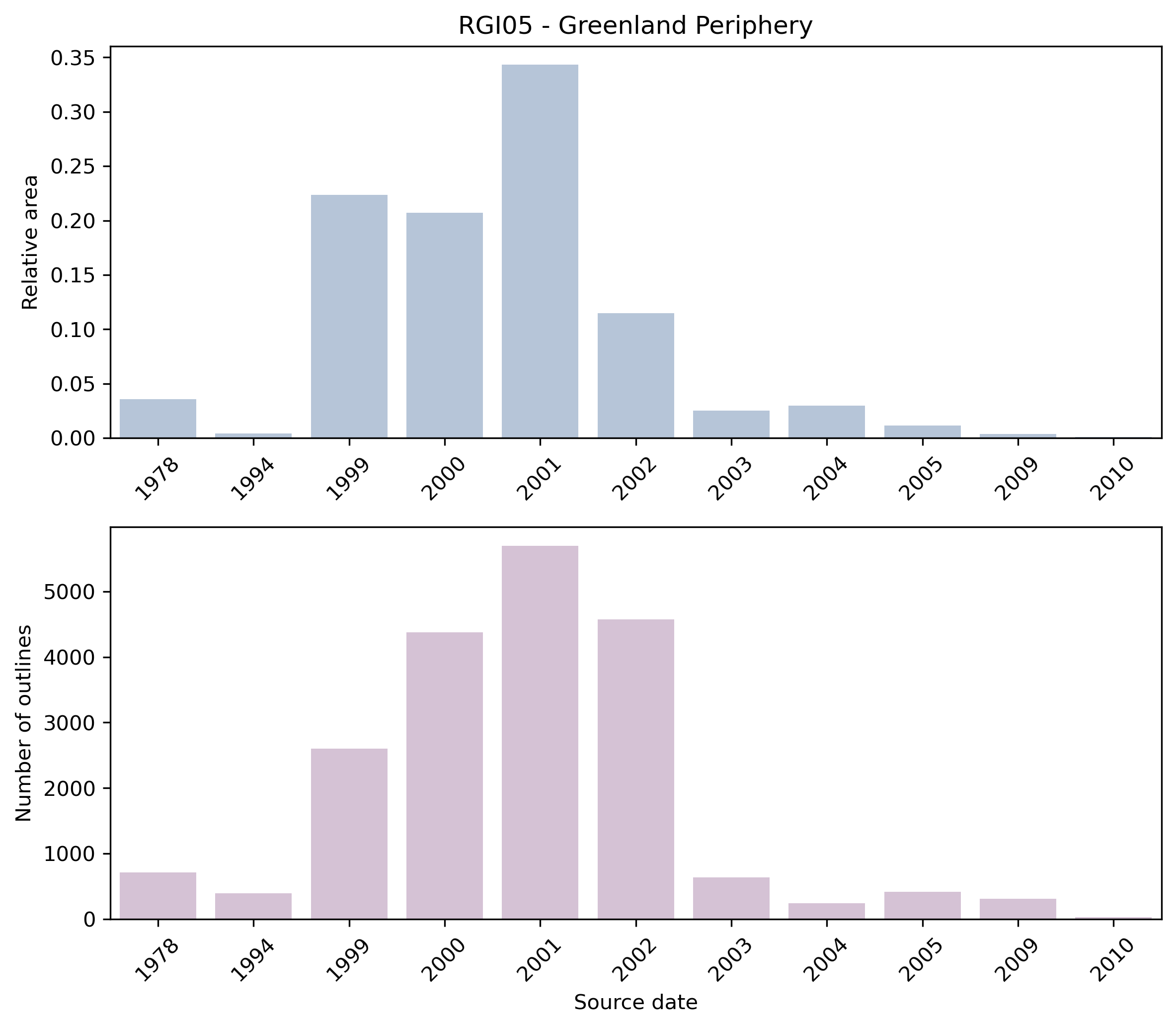
Fig. 27 Distribution of the outline dates per area (top) and number (bottom)#
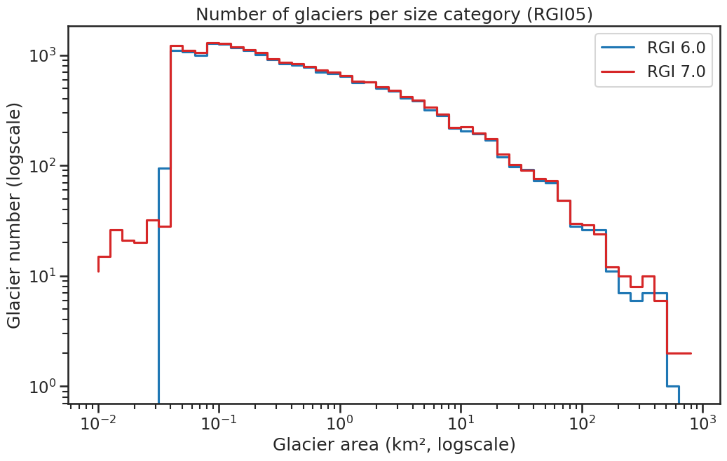
Fig. 28 Number of glaciers per size category (log-log scale).#
Regional number of glaciers (N) and area (km²) per terminus type in RGI 7.0 and RGI 6.0. Note that the default designation in RGI 7.0 is now “Not assigned”, while in RGI 6.0 lake-terminating glaciers and shelf-terminating glaciers were identified in some regions. The RGI region 19 is entirely labelled as “Not assigned” in RGI 7.0.
Value |
Terminus type |
RGI 7.0 (N) |
RGI 6.0 (N) |
RGI 7.0 (Area) |
RGI 6.0 (Area) |
|---|---|---|---|---|---|
0 |
Land-terminating |
0 |
18550 |
0 |
58611 |
1 |
Marine-terminating |
507 |
756 |
25980 |
31106 |
2 |
Lake-terminating |
0 |
0 |
0 |
0 |
3 |
Shelf-terminating |
0 |
0 |
0 |
0 |
9 |
Not assigned |
19487 |
0 |
64502 |
0 |
Regional number of glaciers (N) and area (km²) per surge type attribute in RGI 7.0 and RGI 6.0.
Value |
Surge type |
RGI 7.0 (N) |
RGI 6.0 (N) |
RGI 7.0 (Area) |
RGI 6.0 (Area) |
|---|---|---|---|---|---|
0 |
No evidence |
19901 |
0 |
88407 |
0 |
1 |
Possible |
1 |
0 |
1 |
0 |
2 |
Probable |
71 |
74 |
1069 |
1172 |
3 |
Observed |
21 |
14 |
1005 |
682 |
9 |
Not assigned |
0 |
19218 |
0 |
87863 |
Version history
- Changes from Version 5.0 to 6.0
None.
- Changes from Version 4.0 to 5.0
A link was added to the record of Mittivakkat Glacier in the WGMS mass-balance database.
- Changes from Version 3.2 to 4.0
46 exterior GLIMSIds were replaced. Topographic and hypsometric attributes were added.
19 glaciers appeared twice in version 3.2. One member of each such pair was removed.- Changes from Version 3.0 to 3.2
A planimetric offset was discovered in parts of Greenland in version 3.0. This offset was repaired.
- Changes from Version 2.0 to Version 3.0
Coverage of Greenland is new in version 3.0, and is described in detail by Rastner et al. [2012]. In all, 73 satellite images were processed. Glacier complexes were subdivided using a flowshed algorithm. An enhanced form of the algorithm for identifying glaciers other than the Greenland Ice Sheet was developed. In addition to the connectivity rule described below (see Version 1.0), a “topographic heritage rule” was added. Glaciers adjoining the ice sheet were first assigned to level CL2 (strongly connected) or level CL1 (weakly connected). Unassigned glaciers adjoining one or more level-2 glaciers were then assigned the same connectivity, and likewise for glaciers adjoining level-1 glaciers. The remaining unassigned glaciers, those not connected to the ice sheet at all, were assigned to level CL0.
Glaciers of all three connectivity levels are included in the RGI. Rastner et al. recommend that CL2 glaciers be treated as part of the ice sheet, for which purpose they can be identified using Connect. The total extent of CL0 and CL1 glaciers, 89731 km2, is well in excess of any previous estimate of the extent of glaciers in the Greenland periphery. Adding the CL2 glaciers and the ice sheet, Rastner et al. estimate a glacierized area for Greenland as a whole of 1.808±0.004 × 10⁶ km2. This lies between the two estimates suggested by Kargel et al. [2012], 1.801±0.016 × 10⁶ km2 and 1.824±0.016 × 10⁶ km2; these estimates are statistically indistinguishable from but more uncertain than that of Rastner et al.- Changes from Version 1.0 to Version 2.0
None.
- Version 1.0
Distinguishing between what is considered ice sheet versus glaciers is a challenge, and depends on the scientific application. While the distinction is clear for the numerous fully detached glaciers, there are several regions where, although there is a physical connection to the main ice sheet, the ice mass is either a valley glacier in mountainous terrain, or it forms its own ice dome and is largely uncoupled from the ice sheet dynamics. Therefore, for applications such as extrapolation of laser altimetry data, some researchers consider that such ice masses should be categorized as glaciers rather than as part of the ice sheet.
In the RGI, all ice masses with a possible but uncertain drainage divide are assigned to the ice sheet (e.g. on the Geikie Plateau), and all others to the local (or peripheral) glaciers. The latter are either not connected to the ice sheet at all, clearly separable (e.g. by mountain ridges) in the accumulation region, or only in contact with ice sheet outlets in the ablation region.
Indeed, there is room for discussion on individual decisions, but for the purpose of the RGI we just need to start somewhere. The separation in the accumulation area is done along drainage divides derived from DEM-based watershed analysis.
The glaciers north of ~81°N were not available from Landsat data and were provided by the Greenland Mapping Project [Howat et al., 2014].
The semi-automated glacier mapping applied to the 64 Landsat scenes that were processed is based on a band ratio (ETM+ Band 3/Band 5) with an additional threshold in band 1 for better mapping of glacier areas in cast shadow. It is based on Paul and Kääb [2005] and described for a part of western Greenland in Citterio et al. [2009]. Debris-covered glacier parts as well as wrongly classified sea ice, icebergs or lakes were corrected manually in the vector domain. A 3 by 3 median filter is applied for image smoothing and glaciers smaller than 0.05 km2 are not considered. Wrongly classified regions with seasonal snow could not always be corrected.