03: Arctic Canada North#
The region encompasses all glaciers in Canada north of 74°N including the heavily glacierized Ellesmere and Devon Islands.
Subregions
03-01: North Ellesmere Island
03-02: Axel Heiberg and Meighen Island
03-03: North Central Ellesmere Island
03-04: South Central Ellesmere Island
03-05: South Ellesmere Island (Northwest Devon)
03-06: Devon Island
03-07: Melville Island
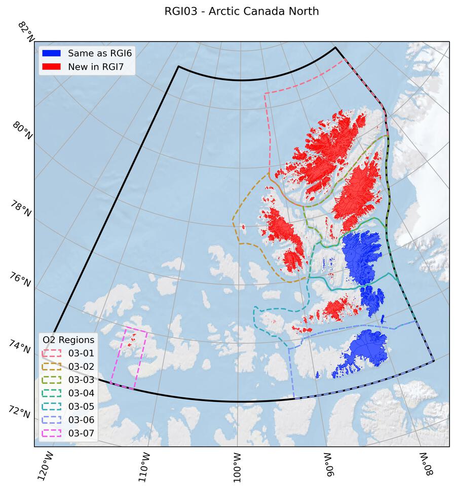
Fig. 17 Regional glacier area. Download high resolution version.#
Changes from version 6.0 to 7.0#
Ellesmere Island: Second-order region 03-01
Glacier outlines and ice divdes were replaced as RGI 6.0 outlines suffered from incorrect ice divides, missing rock outcrops, missing (mostly very small) glaciers and a geolocation shift. Glaciers were remapped using glacier outlines by White [2019] as a base but modifying them using four Landsat ETM+ scenes acquired in July 2000. The editing included a mix of manual and automated corrections. For the northernmost regions outside the coverage of Landsat the “World imagery” layer of the ESRI Basemap was used instead. Some smaller ice shelves were excluded.
Other regions
For other subregions on Ellesmere Island as well as the Axel Heiberg Island ice caps, Sydkap Ice Cap, Agassiz Ice Cap, and glaciers west of Sydkap, and west of Manson Ice Field, RGI 6.0 outlines were adjusted to improve their quality, and glacier divides were replaced. Several previously omitted glaciers west of Prince of Wales Ice Cap were added.
Additional information#
Data sources and analysts
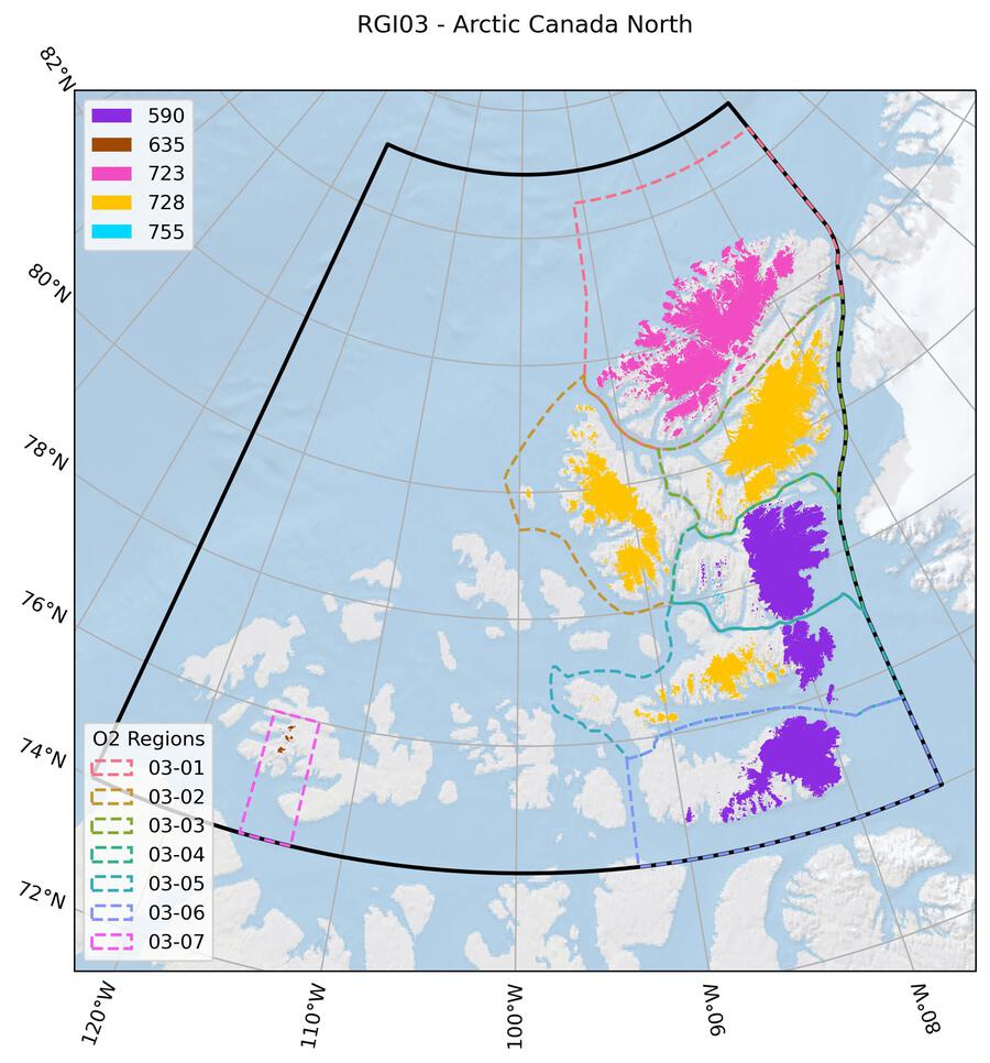
Fig. 18 Submission IDs used for this region Download high resolution version.#
Glacier outline providers to GLIMS
This list includes the providers of the outlines used in the RGI 7.0 as generated automatically from the GLIMS outlines metadata. We acknowledge that the list may be incomplete due to omissions in the GLIMS database.
- Submission 590
Submitter: Bolch, Tobias.
Number of outlines: 652. Area: 39842.3km². Release date: 2015-07-15.
Analysts: Barrand, Nick; Burgess, Dave; Cawkwell, Fiona; Copland, Luke; Filbert, Katie; Gardner, Alex; Hartmann, G; OCallaghan, P; Paul, Frank; Sharp, Martin; Wolken, G.; Wyatt, F..- Submission 635
Submitter: Cogley, Graham.
Number of outlines: 7. Area: 128.2km². Release date: 2015-07-16.
Analysts: Berthier, Etienne; Bolch, Tobias; Cogley, Graham; Kienholz, Christian.- Submission 723
Submitter: Paul, Frank.
Number of outlines: 2573. Area: 27690.4km². Release date: 2021-09-03.
Analysts: Paul, Frank; Rastner, Philipp; White, Adrienne.- Submission 728
Submitter: Kochtitzky, William.
Number of outlines: 1961. Area: 37675.5km². Release date: 2021-08-27.
Analysts: Copland, Luke; Kochtitzky, William; Thomson, Laura; Zajaczkiwsky, Sophie.- Submission 755
Submitter: Kochtitzky, William.
Number of outlines: 23. Area: 33.9km². Release date: 2021-12-26.
Analysts: Kochtitzky, William.- Reviewers
Kochtitzky, William;
Regional statistics
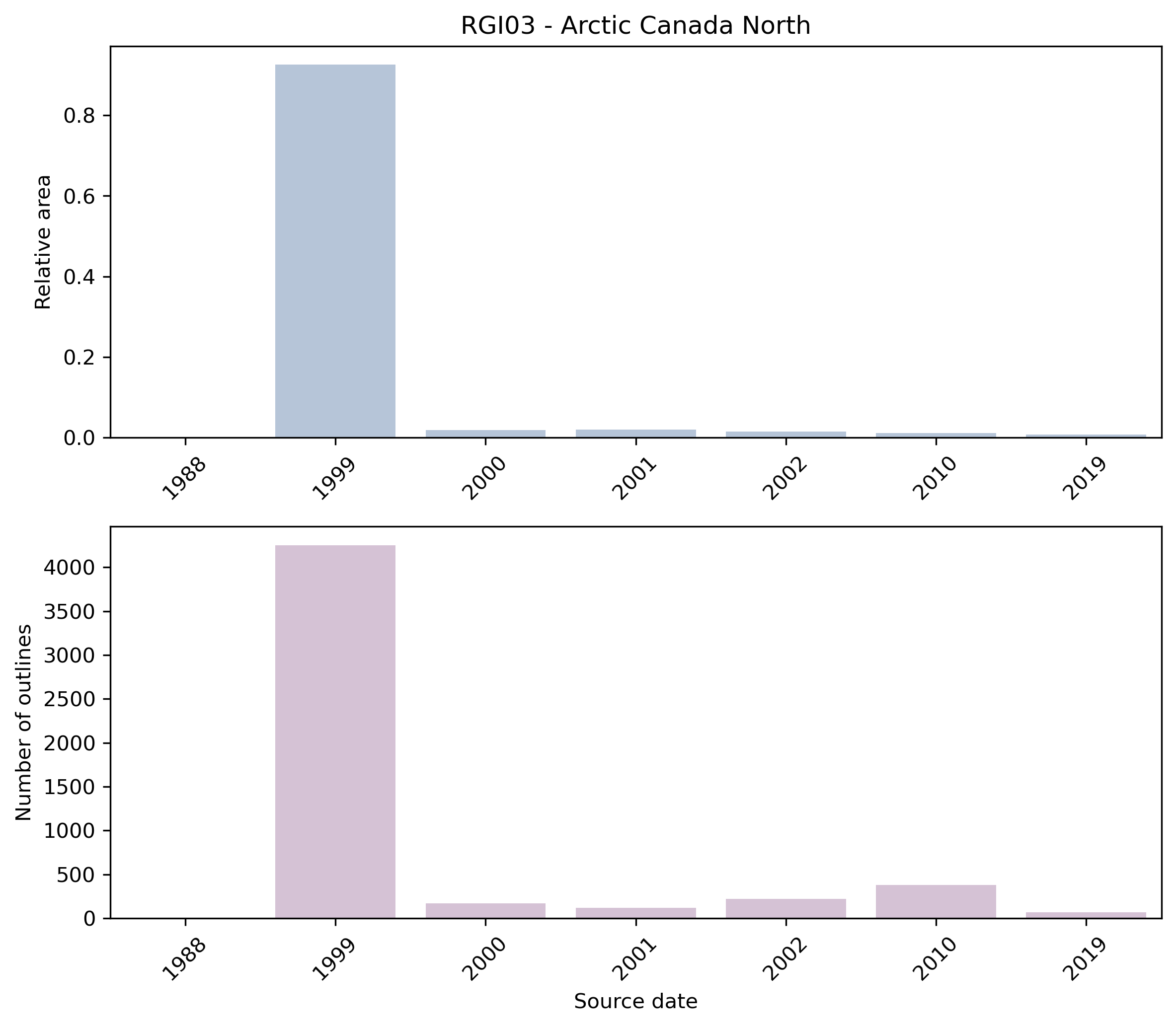
Fig. 19 Distribution of the outline dates per area (top) and number (bottom)#
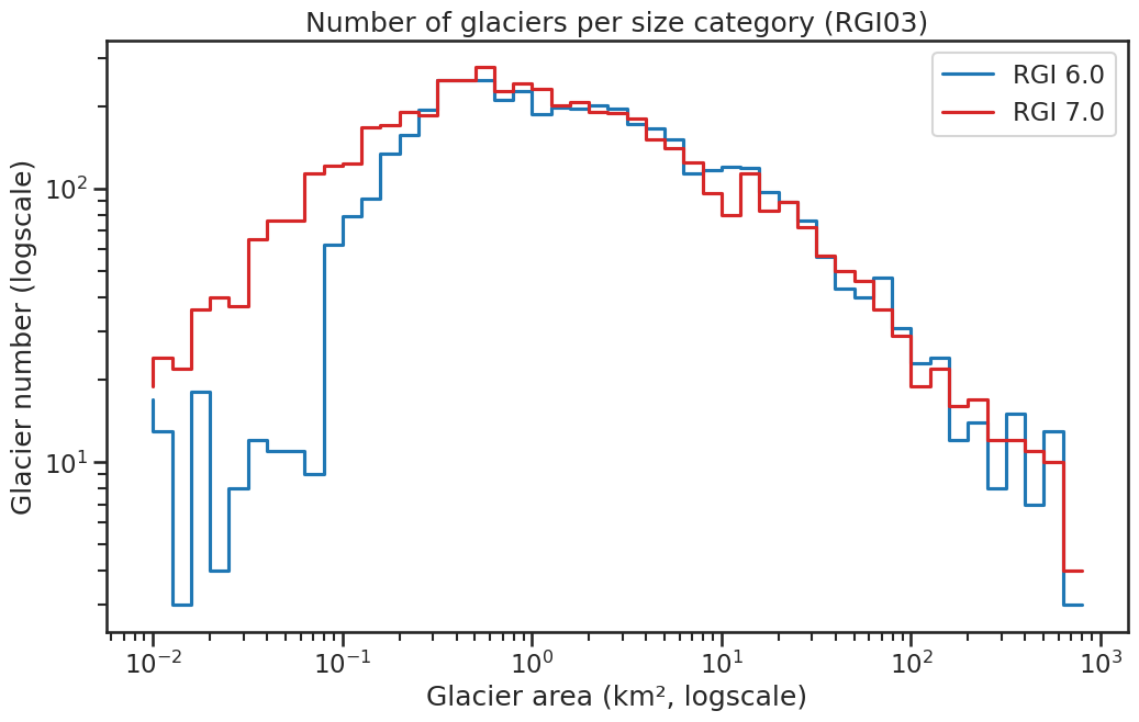
Fig. 20 Number of glaciers per size category (log-log scale).#
Regional number of glaciers (N) and area (km²) per terminus type in RGI 7.0 and RGI 6.0. Note that the default designation in RGI 7.0 is now “Not assigned”, while in RGI 6.0 lake-terminating glaciers and shelf-terminating glaciers were identified in some regions. The RGI region 19 is entirely labelled as “Not assigned” in RGI 7.0.
Value |
Terminus type |
RGI 7.0 (N) |
RGI 6.0 (N) |
RGI 7.0 (Area) |
RGI 6.0 (Area) |
|---|---|---|---|---|---|
0 |
Land-terminating |
0 |
4298 |
0 |
56000 |
1 |
Marine-terminating |
238 |
258 |
49691 |
49111 |
2 |
Lake-terminating |
0 |
0 |
0 |
0 |
3 |
Shelf-terminating |
0 |
0 |
0 |
0 |
9 |
Not assigned |
4978 |
0 |
55680 |
0 |
Regional number of glaciers (N) and area (km²) per surge type attribute in RGI 7.0 and RGI 6.0.
Value |
Surge type |
RGI 7.0 (N) |
RGI 6.0 (N) |
RGI 7.0 (Area) |
RGI 6.0 (Area) |
|---|---|---|---|---|---|
0 |
No evidence |
5145 |
4499 |
69295 |
75945 |
1 |
Possible |
34 |
25 |
13457 |
12279 |
2 |
Probable |
16 |
11 |
5639 |
4098 |
3 |
Observed |
21 |
15 |
16979 |
12731 |
9 |
Not assigned |
0 |
6 |
0 |
59 |
Version history
- Changes from Version 5.0 to 6.0
Glacier complex RGI50-03.04540, added in version 5.0, was subdivided into 11 outlet glaciers with ids 03.04541 to 03.04551. The seven glaciers on Melville Island were transferred from former region 02-01 to region 03-07, with ids 03.04552 to 03.04558.
The source for hypsometry was changed from the ASTER GDEM2 to the ViewfinderPanoramas DEM3.- Changes from Version 4.0 to 5.0
Names were assigned to some glaciers on Axel Heiberg Island. Glacier RGI40-03.00840 was subdivided into RGI50-03.04538 (Thompson Glacier) and RGI50-03.04539 (White Glacier). Alexander Trishchenko (Canada Centre for Remote Sensing, Ottawa) pointed out that an ice cap of 126 km2 on Colin Archer Peninsula, northwest Devon Island was missing, and it was added (RGI50-03.04540).
Links were added to 4 glaciers in the WGMS mass-balance database.- Changes from Version 3.2 to 4.0
One exterior GLIMSId was replaced. Topographic and hypsometric attributes were added.
- Changes from Version 3.0 to 3.2
Glaciers were delineated from the glacier complexes using the delineation algorithm developed by Kienholz et al. [2013] and applied to the 1:250000 Canadian Digital Elevation Data (CDED). Some minor manual editing was done to remove obvious blunders.
- Changes from Version 2.0 to 3.0
None
- Changes from Version 1.0 to Version 2.0
Canvec outlines of the Melville Island glaciers, which were mistakenly duplicated in region 03 in version 1.0, were transferred to region 02.
- Version 1.0
Glacier outlines were created from late summer, cloud-free 1999-2003 Landsat 7 (ETM+) imagery and from 2000-2003 ASTER imagery. A normalized-difference snow index (NDSI) was calculated for all Landsat imagery to identify snow- and ice-covered terrain. Empirically derived thresholds were applied to refine these classifications and to separate snow from glacier ice. A clumping procedure was then applied to the classified snow and ice data to delineate contiguous groups of pixels, followed by an elimination procedure, which removed small clusters of non-ice pixels. Gridded snow and ice data were then converted to polygons and edited manually to correct misclassifications. Small portions of some areas within this region were not adequately imaged by Landsat, due to either persistent cloudiness or shadowing. Consequently, in these areas manual digitization of ASTER imagery was used to capture glacier outlines.
Outlines for Devon Island were provided by D. Burgess and were derived from 1999/2000 velocity maps.