Glacier product#
This product includes the glacier outlines as extracted from GLIMS together with additional data for each individual glacier.
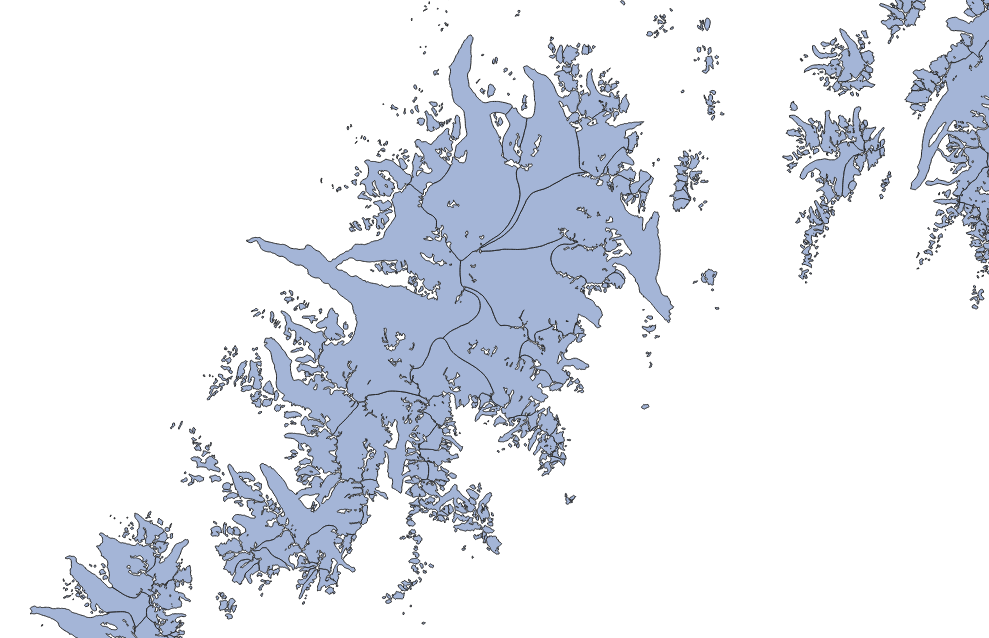
Fig. 2 Example of the glacier product (light blue), with outlines in black.#
Product files#
In the following, file contents are explained using RGI region 01 (Alaska) as example:
RGI2000-v7.0-G-01_alaska.shpRGI glacier outlines as a shapefile (with accompanying
.dbf,.prj,.cpgand.shxfiles).RGI2000-v7.0-G-01_alaska-attributes.csvGlacier attributes in a
.csvfile. The attributes are strictly the same as those encountered in the shapefile. This file allows users to read glacier attributes without reading the entire shapefile.RGI2000-v7.0-G-01_alaska-attributes_metadata.jsonDescription of the attributes in the glacier product shapefile: full name, description, units, etc. The content of this file is displayed in Full list of attributes below.
RGI2000-v7.0-G-01_alaska-submission_info.csvInformation about the data providers ordered by submission identifier (
subm_id). Each glacier outline can be attributed to a specific submission via theirsubm_idattribute.RGI2000-v7.0-G-01_alaska-submission_info_metadata.jsonDescription of the columns in the
submission_info.csvfile: full name, description, units, etc. The content of this file is displayed in Submission info table below.RGI2000-v7.0-G-01_alaska-rgi6_links.csvA list of all overlaps (greater than 200 m2) between pairs of RGI 7.0 and RGI 6.0 glacier outlines, described by the following columns:
Column
Type
Description
rgi7_idstring
RGI 6.0 outline identifier
rgi6_idstring
RGI 7.0 outline identifier
rgi7_regstring
RGI 7.0 region identifier
rgi6_regstring
RGI 6.0 region identifier
overlap_area_km2number
Overlap area in km2
rgi7_area_fractionnumber
Overlap area (
overlap_area_km2) divided by the area of the RGI 7.0 outline (rgi7_id)rgi6_area_fractionnumber
Overlap area (
overlap_area_km2) divided by the area of the RGI 60 outline (rgi6_id)n_rgi7integer
Total number of RGI 7.0 outlines that overlap the RGI 6.0 outline (
rgi6_id)n_rgi6integer
Total number of RGI 6.0 outlines that overlap the RGI 7.0 outline (
rgi7_id)cluster_idinteger
Arbitrary cluster identifier (unique globally), which groups together all overlapping RGI 6.0 and RGI 7.0 outlines such that each cluster does not overlap any other cluster
For example, if an RGI 6.0 outline perfectly matches an RGI 7.0 outline, the overlap is a 1:1 relation (
n_rgi6: 1,n_rgi7: 1) with 100% coverage (rgi7_area_fraction: 1,rgi6_area_fraction: 1). If an RGI 6.0 outline divided into two outlines (of equal area) in RGI 7.0, the two overlaps are part of a 1:2 relation (n_rgi6: 1,n_rgi7: 2) with 50% and 100% coverage (rgi6_area_fraction: 0.5,rgi7_area_fraction: 1). Often the relation between RGI 7.0 and RGI 6.0 is more complex, for example when an outline was remapped in RGI 7.0 and partially overlaps many in RGI 6.0. Note that in some cases (mostly in regions 13, 14, 15), an RGI 7.0 outline might overlap with an RGI 6.0 outline in a neighboring region.RGI2000-v7.0-G-01_alaska-hypsometry.csvHypsometry for each glacier, preceded by copies of the glacier’s
rgi_idandarea_km2. The hypsometry data are given as a comma-separated series of elevation-band areas in the form of integer thousandths of the glacier’s total area in km² (area_km2). The sum of the elevation-band area values is constrained to be 1000. This means that an elevation band’s value divided by 10 represents the elevation band’s area as a percentage of total glacier area. For example, a value of 500 for a particular elevation bands means that it contains 50% of the total glacier area. The elevation bands are all 50 m in height and their central elevations are listed in the file header record. Within each hypsometry file the elevation bands extend from the lowest glacierized elevation up to the highest glacierized elevation band of the corresponding first-order region.
Full list of attributes#
The following attributes are available in the RGI 7.0 shapefiles. For more details, see Additional information on glacier attributes.
rgi_idlong_name: RGI identifier
description: Unique identifier assigned to a single outline.
datatype: str
units:
source: RGI
rgi6_name: RGI_Ido1regionlong_name: First order region
description: The code of the first-order region to which the glacier belongs.
datatype: str
units:
source: RGI
rgi6_name: O1Regiono2regionlong_name: Second order region
description: The code of the second-order region to which the glacier belongs.
datatype: str
units:
source: RGI
rgi6_name: O2Regionglims_idlong_name: GLIMS identifier
description: Non-unique identifier assigned to glaciers by the Global Land Ice Measurements from Space service at NSIDC.
datatype: str
units:
source: GLIMS
rgi6_name: GLIMS_Idanlys_idlong_name: Analysis identifier
description: The unique identifier assigned within GLIMS for a particular outline of a glacier at a particular time.
datatype: int
units:
source: GLIMS
rgi6_name:subm_idlong_name: Submission identifier
description: Unique identifier assigned by GLIMS to a specific data submission. Allows to obtain information about the analysts and data submitters.
datatype: int
units:
source: GLIMS
rgi6_name:src_datelong_name: Outline source date
description: The as-of date for the outline (usually the acquisition date of the image), in the format ISO 8601.
datatype: str
units: date
source: GLIMS
rgi6_name: BgnDatecenlonlong_name: Center longitude
description: Longitude of an approximately central point within the glacier outlines (not the centroid).
datatype: float
units: degrees
source: RGI
rgi6_name: CenLoncenlatlong_name: Center latitude
description: Latitude of an approximately central point within the glacier outlines (not the centroid).
datatype: float
units: degrees
source: RGI
rgi6_name: CenLatutm_zonelong_name: UTM zone
description: Number of the UTM zone for this glacier, based on its representative point. Note that this attribute is for information only, the geometries are all in WGS84.
datatype: int
units:
source: RGI
rgi6_name:area_km2long_name: Glacier area
description: Area of the glacier.
datatype: float
units: km2
source: RGI
rgi6_name: Areaprimeclasslong_name: Primary classification
description: WGMS primary classification of the glacier. For a categories description, see user guide.
datatype: int
units:
source: GLIMS
rgi6_name:conn_lvllong_name: Connectivity level
description: Level of connection to the Greenland Icesheet (0: no connection; 1: weak connection).
datatype: int
units:
source: GLIMS
rgi6_name: Connectsurge_typelong_name: Evidence for surging
description: Flag indicating if surging behavior has been documented for this glacier. For a categories description, see user guide.
datatype: int
units:
source: GLIMS
rgi6_name: Surgingterm_typelong_name: Glacier terminus type
description: Flag indicating the terminus type of the glacier. For a categories description, see user guide.
datatype: int
units:
source: GLIMS
rgi6_name: TermTypeglac_namelong_name: Glacier name
description: Glacier name (when available).
datatype: str
units:
source: GLIMS
rgi6_name: Nameis_rgi6long_name: Same as RGI 6.0 outline
description: Flag indicating if the outline is the same as in RGI 6.0 (1) or was remapped (0). Note that it does not guarantee strict equivalence of the polygon (in most of the cases it does).
datatype: int
units:
source: RGI
rgi6_name:termlonlong_name: Terminus longitude
description: Longitude of the lowest elevation point on the glacier outline.
datatype: float
units: degrees
source: RGI
rgi6_name:termlatlong_name: Terminus latitude
description: Latitude of the lowest elevation point on the glacier outline.
datatype: float
units: degrees
source: RGI
rgi6_name:zmin_mlong_name: Minimum elevation
description: Minimum elevation (m above sea level) of the glacier.
datatype: float
units: m
source: RGI
rgi6_name: Zminzmax_mlong_name: Maximum elevation
description: Maximum elevation (m above sea level) of the glacier.
datatype: float
units: m
source: RGI
rgi6_name: Zmaxzmed_mlong_name: Median elevation
description: Median elevation (m above sea level) of the glacier.
datatype: float
units: m
source: RGI
rgi6_name: Zmedzmean_mlong_name: Mean elevation
description: Mean elevation (m above sea level) of the glacier.
datatype: float
units: m
source: RGI
rgi6_name:slope_deglong_name: Mean slope
description: Mean slope of the glacier surface.
datatype: float
units: degrees
source: RGI
rgi6_name: Slopeaspect_deglong_name: Aspect
description: The aspect (orientation) of the glacier surface presented as an azimuth relative to 0° at due north.
datatype: float
units: degrees
source: RGI
rgi6_name: Aspectaspect_seclong_name: Aspect sector
description: The aspect (orientation) of the glacier surface presented as a category. For a categories description, see user guide.
datatype: int
units:
source: RGI
rgi6_name:dem_sourcelong_name: DEM data source
description: The name of the dataset that was used to compute the topography attributes.
datatype: str
units:
source: RGI
rgi6_name:lmax_mlong_name: Maximum length
description: Length (m) of the longest surface centerline of the glacier.
datatype: int
units: m
source: RGI
rgi6_name: Lmaxgeometrylong_name: Geometry
description: Glacier geometry (Polygon)
datatype:
units: deg
source: GLIMS
rgi6_name: geometry
Additional information on glacier attributes#
Glacier identifiers#
One RGI outline in the glacier product corresponds to one glacier. Glaciers are identified with the following attributes:
rgi_idUnique identifier attributed by the RGI when constructing the files. These ids are generated automatically (in order of distance to the westernmost outline in a region) and follow the file naming convention described below. These ids are different from RGI 6.0 and likely to change in future RGI versions.
glims_idNon-unique identifier assigned to glaciers by the Global Land Ice Measurements from Space service at NSIDC. A single
glims_idcan have multiple outlines, for example at different dates or when a glacier disintegrates.anlys_idUnique identifier assigned within GLIMS for a particular outline of a glacier at a particular time and for a particular submission. These ids allow to unambiguously trace an outline back to the GLIMS database, and will not change between future RGI versions if the outline does not change.
Topography attributes#
The zmin_m, zmax_m, zmed_m, zmean_m attributes are computed from a Digital Elevation Model (DEM) reprojected onto a locally defined grid for each glacier. The gridded dataset used to compute these attributes (RGI-TOPO) is documented and available on the OGGM documentation.
Each glacier grid is defined in the locally valid UTM zone (utm_zone attribute) and with a grid spacing \(dx\) depending on the glacier size: \(dx = 14 \sqrt{A} + 10\), with \(dx\) the grid spacing in meters and \(A\) the glacier area in km² [Maussion et al., 2019]. If a grid spacing chosen by this formula exceeds 100 m, the grid spacing is fixed to a maximum of 100 m. Effectively, this means that a glacier of the minimum area of 0.01 km² will have a grid spacing of 11.4 m, a 8 km² glacier a grid spacing of 50 m, and all glaciers above 42 km² a grid spacing of 100 m. The chosen DEM product (dem_source attribute) is reprojected onto the local glacier grid and interpolated using cubic resampling with the rasterio library.
The main DEM product used for RGI 7.0 is the Copernicus DEM [Copernicus, 2019] (used for all but 128 glaciers). The COP-DEM products are available at 30 m and 90 m resolution. For all glaciers which grid size is below 60 m we use the 30 m COP-DEM product as source, and use the 90 m COP-DEM product for all other glaciers. If the COP-DEM product is not available for a glacier, we use one of the alternative products RAMP (21 glaciers), DEM3 (20 glaciers), ASTER (14 glaciers), or TANDEM (73 glaciers). We ask our users to refer to the original data sources in their publications if the topography attributes derived from RGI 7.0 play a significant role: refer to DEM products citations for a full reference.
For each glacier, a glacier mask is computed from the outlines and then applied to compute the glacier statistics.
Slope attributes#
The slope_deg, aspect_deg, aspect_sec attributes are computed from the same DEM and grid as for the topography attributes described above (RGI-TOPO).
slope_deg and aspect_deg are computed using a standard trigonometric functions in python. The aspect_sec attribute contains information on the orientation of the glacier, classified into the following categories:
Value |
Aspect sector |
Aspect range |
|---|---|---|
1 |
North |
[337.5°; 22.5°] |
2 |
North-east |
[22.5°; 67.5°] |
3 |
East |
[67.5°; 112.5°] |
4 |
South-east |
[112.5°; 157.5°] |
5 |
South |
[157.5°; 202.5°] |
6 |
South-west |
[202.5; 247.5°] |
7 |
West |
[247.5°; 292.5°] |
8 |
North-west |
[292.5°; 337.5°] |
9 |
Not assigned |
Terminus location#
The termlon, termlat attributes mark the longitude and latitude of the last point of the main centerline, guaranteed to be on the glacier outline. It represents (approximately) the location of lowest elevation along the glacier outline. Knowing the terminus location is useful to assign a glacier to a hydrological basin, for example.
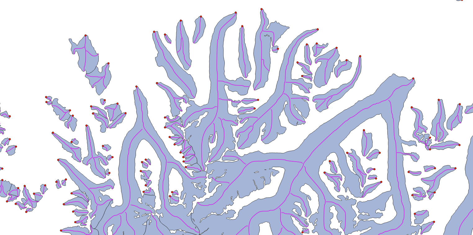
Fig. 3 Example of the glacier terminus location (red dots) plotted with the centerlines product (purple) drawn over the glacier product (light blue).#
Glacier length#
The maximum length (lmax_m, in meters) is computed from the main centerline in the RGI 7.0 glacier centerline product. Absolute glacier length is a subjective measure, and principally depends on the chosen “head” of the glacier. The head is distinct from the maximum elevation of the glacier. The centerline algorithm from Kienholz et al. [2014] selects potential heads by searching for local maxima along the glacier outline, and then computes all the centerlines joining all heads to the single terminus. The longest of them is selected as the main centerline, which implies that the computed glacier length is often longer than the shortest route from the highest to the lowest point of the glacier.
Surge type#
The surge_type attribute contains information on evidence for surging, and is based on the following datasets:
All glaciers marked as surge-type in RGI 6.0;
The global inventory of Sevestre and Benn [2015];
An inventory of surge-type glaciers in the Karakoram from Bhambri et al. [2017] (region 14);
An inventory of observed glacier surges in the Pamirs from Goerlich et al. [2020] (region 13);
An inventory of High Mountain Asia surge-type glaciers from Guillet et al. [2022] (regions 13, 14, 15);
Additional inventories compiled by Ruth Krembel, Andreas Kääb, and Frank Paul.
Each inventory was intersected with the RGI 7.0 outlines. For inventories with glacier outlines, intersections smaller than 5% by area were discarded. For inventories with point data, where no intersection was found, the closest glacier to the point was manually chosen based on a comparison with the metadata provided with each inventory. Finally, each glacier in the RGI 7.0 was then assigned the category corresponding to the highest level of confidence based on each inventory (i.e., “observed” > “probable” > “possible” > “not assigned”).
Value |
Surging |
|---|---|
0 |
No evidence |
1 |
Possible |
2 |
Probable |
3 |
Observed |
9 |
Not assigned |
Visit Global attributes statistics for glacier counts/area of this attribute in RGI 7.0 and RGI 6.0.
Terminus type#
The term_type attribute contains information on terminus type. All glaciers in RGI 7.0 have been assigned the “Not assigned” category, except
for the marine-terminating glaciers in the northern hemisphere (after Kochtitzky et al. [2022]) and in region 17 - Southern Andes (same methodology).
The marine-terminating term_type attribute is valid for approximately the year 2000.
The only region missing classification for marine-terminating glaciers is RGI 19 (Antarctic and Subantarctic),
thus all glaciers that are “not assigned” outside of RGI 19 can be assumed to be land- or lake-terminating for the mapped year.
As of RGI 7.0, no region or glacier has any attributes available for lake-terminating or shelf-terminating glaciers. We aim to add this information in a future update of the RGI.
Value |
Terminus type |
|---|---|
0 |
Land-terminating |
1 |
Marine-terminating |
2 |
Lake-terminating |
3 |
Shelf-terminating |
9 |
Not assigned |
Visit Global attributes statistics for glacier counts/area of this attribute in RGI 7.0 and RGI 6.0.
WGMS primary classification#
The WGMS primary classification of the glacier (primeclass) is directly fetched from the GLIMS database. It is currently poorly populated, with only few submissions to GLIMS having provided this information.
Digit |
Class |
Description |
|---|---|---|
0 |
Miscellaneous |
Any type not listed below (please explain) |
1 |
Continental ice sheet |
Inundates areas of continental size |
2 |
Icefield |
Ice masses of sheet or blanket type of a thickness that is insufficient to obscure the subsurface topography |
3 |
Ice cap |
Dome-shaped ice masses with radial flow |
4 |
Outlet glacier |
Drains an ice sheet, icefield or ice cap, usually of valley glacier form; the catchment area may not be easily defined |
5 |
Valley glacier |
Flows down a valley; the catchment area is well defined |
6 |
Mountain glacier |
Cirque, niche or crater type, hanging glacier; includes ice aprons and groups of small units |
7 |
Glacieret and snowfield |
Small ice masses of indefinite shape in hollows, river beds and on protected slopes, which has developed from snow drifting, avalanching, and/or particularly heavy accumulation in certain years; usually no marked flow pattern is visible; in existence for at least two consecutive years. |
8 |
Ice shelf |
Floating ice sheet of considerable thickness attached to a coast nourished by a glacier(s); snow accumulation on its surface or bottom freezing |
9 |
Rock glacier |
Lava-stream-like debris mass containing ice in several possible forms and moving slowly downslope |
Submission info table#
Each glacier region folder contains a csv file containing information about provenance of the glacier outlines. This file is available for the glacier product only, and allows to associate each outline’s subm_id (submission identifier) to a specific entry in the GLIMS database. The table contains the following columns:
subm_idlong_name: submission_id
description: Unique identifier assigned by GLIMS to a specific data submission. Allows to obtain information about the analysts and data submitters.
datatype: int
units:
source: GLIMS
rgi6_name:n_outlineslong_name: number_of_outlines
description: Number of outlines from this submission used in RGI 7.0.
datatype: int
units:
source: RGI
rgi6_name:area_km2long_name: total_area_of_outlines
description: Total area of the outlines from this submission used in RGI 7.0.
datatype: float
units: km2
source: RGI
rgi6_name:anlys_timelong_name: analysis_time
description: Representative time the outline analysis was carried out.
datatype: str
units: date
source: GLIMS
rgi6_name:release_dtlong_name: release_date
description: Date at which the submission was realeased on GLIMS.
datatype: str
units: date
source: GLIMS
rgi6_name:proc_desclong_name: processing_description
description: Description of the processing done to create the glacier outlines.
datatype: str
units:
source: GLIMS
rgi6_name:chief_affllong_name: chief_affiliation
description: Affiliation of the chief of the regional center or the person(s) who submitted the data.
datatype: str
units:
source: GLIMS
rgi6_name:submitterslong_name: submitters
description: Person(s) who submitted the data.
datatype: str
units:
source: GLIMS
rgi6_name:analystslong_name: analysts
description: Person(s) who created the data.
datatype: str
units:
source: GLIMS
rgi6_name:rc_idlong_name: regional_center_id
description: GLIMS ID for the regional center.
datatype: int
units:
source: GLIMS
rgi6_name: