10: North Asia#
The region encompasses all glaciers in Asia not included in regions 09 and 12 to 15.
Subregions
10-01: Ural Mountains
10-02: Central Siberia
10-03: Cherskiy/Suntar Khayata Ranges
10-04: Altay and Sayan
10-05: Northeast Russia
10-06: East Chukotka
10-07: Japan
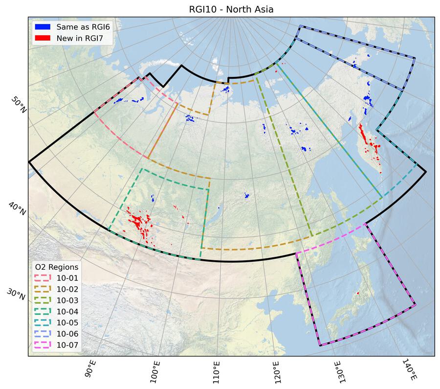
Fig. 45 Regional glacier area. Download high resolution version.#
Changes from version 6.0 to 7.0#
Altay and Sayan
All glacier outlines in Altay and Sayan (subregion 10-04) were replaced by GAMDAM inventory version 2 [Sakai, 2019].
Kamchatka
All glacier outlines in Kamchatka (southern part of subregion 10-05) were remapped. The main issues with RGI 6.0 were related to wrongly included seasonal snow and rock glaciers as well as missing debris-covered and other small glaciers. Several new datasets became available after RGI6.0 including the dataset by Lynch et al. [2016] mostly based on year 2000 outlines, the dataset for the period 2007-2019 described in the review by Khromova et al. [2019] with local corrections by A.Y. Muraviev, and an ASTER-derived dataset from 2002 just for the “Middle Range” of Kamchatka provided by T. Khromova. These datasets were collectively analyzed and edited using Landsat 7 panchromatic images from 2000 and 2002 as well as the “World imagery” layer of the ESRI Basemap for most of the regions. The latter images were mostly used to distinguish debris-covered glaciers from rock glaciers and to identify small ice bodies that were not included in previous inventories due to complete snow cover. The AW3D30 DEM was used to create a flow direction grid for correction of ice divides.
De Long Islands
Glaciers in the De Long Islands, Russia (subregion 10-03), were nominal circles in RGI 6.0, and are now appropriately included with digitized boundaries and divides based on Landsat imagery from 1999.
Japan
Five small glaciers (subregion 10-07) that have been recently documented [Arie et al., 2022] were added. Outline dates range from 1996 to 2019, with most of the area (~80%) dating to 1998-2002.
Additional information#
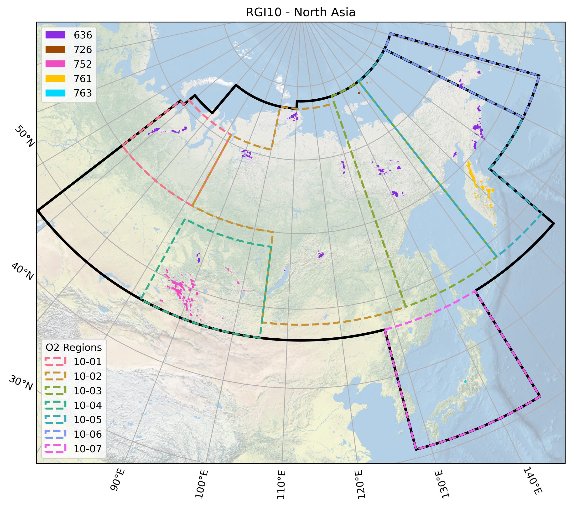
Data sources and analysts

Fig. 46 Submission IDs used for this region Download high resolution version.#
Glacier outline providers to GLIMS
This list includes the providers of the outlines used in the RGI 7.0 as generated automatically from the GLIMS outlines metadata. We acknowledge that the list may be incomplete due to omissions in the GLIMS database.
- Submission 636
Submitter: Cogley, Graham.
Number of outlines: 1646. Area: 394.0km². Release date: 2015-07-16.
Analysts: Cogley, Graham; Earl, Lucas; Gardner, Alex; Raup, Bruce H..- Submission 726
Submitter: Kochtitzky, William.
Number of outlines: 12. Area: 73.0km². Release date: 2021-09-01.
Analysts: Kochtitzky, William.- Submission 752
Submitter: Sakai, Akiko.
Number of outlines: 3001. Area: 1245.2km². Release date: 2018-08-24.
Analysts: Sakai, Akiko.- Submission 761
Submitter: Paul, Frank.
Number of outlines: 2491. Area: 929.9km². Release date: 2022-05-11.
Analysts: Barr, Iestyn; Khromova, Tatiana; Muraviev, Anton; Paul, Frank; Rastner, Philipp.- Submission 763
Submitter: Arie, Kenshiro.
Number of outlines: 5. Area: 0.5km². Release date: 2022-07-20.
Analysts: Arie, Kenshiro.- Reviewers
Barr, Iestyn; Khromova, Tatiana;
Regional statistics
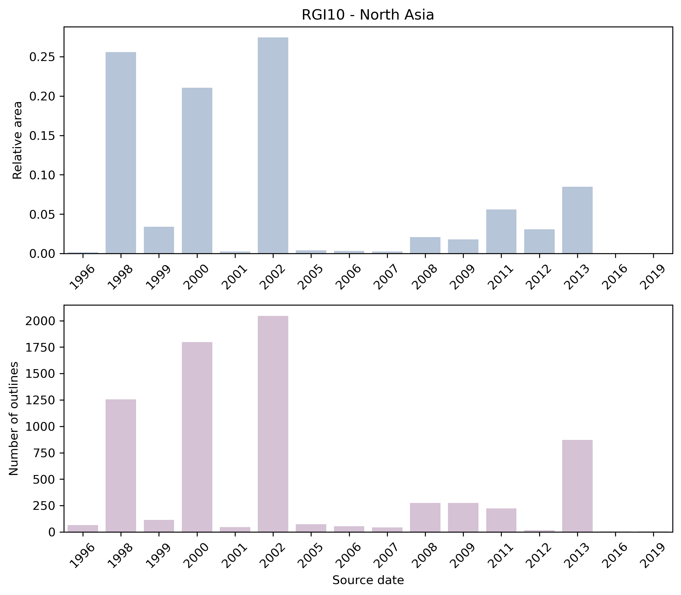
Fig. 47 Distribution of the outline dates per area (top) and number (bottom)#
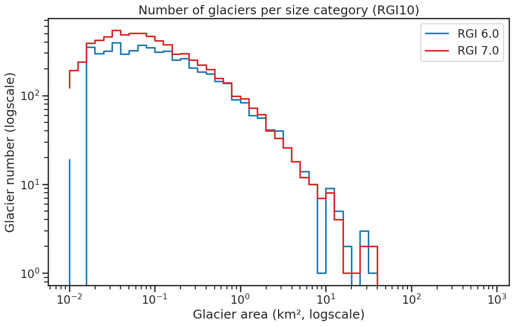
Fig. 48 Number of glaciers per size category (log-log scale).#
Regional number of glaciers (N) and area (km²) per terminus type in RGI 7.0 and RGI 6.0. Note that the default designation in RGI 7.0 is now “Not assigned”, while in RGI 6.0 lake-terminating glaciers and shelf-terminating glaciers were identified in some regions. The RGI region 19 is entirely labelled as “Not assigned” in RGI 7.0.
Value |
Terminus type |
RGI 7.0 (N) |
RGI 6.0 (N) |
RGI 7.0 (Area) |
RGI 6.0 (Area) |
|---|---|---|---|---|---|
0 |
Land-terminating |
0 |
5149 |
0 |
2408 |
1 |
Marine-terminating |
1 |
2 |
14 |
3 |
2 |
Lake-terminating |
0 |
0 |
0 |
0 |
3 |
Shelf-terminating |
0 |
0 |
0 |
0 |
9 |
Not assigned |
7154 |
0 |
2628 |
0 |
Regional number of glaciers (N) and area (km²) per surge type attribute in RGI 7.0 and RGI 6.0.
Value |
Surge type |
RGI 7.0 (N) |
RGI 6.0 (N) |
RGI 7.0 (Area) |
RGI 6.0 (Area) |
|---|---|---|---|---|---|
0 |
No evidence |
7151 |
0 |
2536 |
0 |
1 |
Possible |
0 |
0 |
0 |
0 |
2 |
Probable |
0 |
0 |
0 |
0 |
3 |
Observed |
4 |
2 |
106 |
19 |
9 |
Not assigned |
0 |
5149 |
0 |
2391 |
Version history
- Changes from Version 5.0 to 6.0
For some glaciers the source for hypsometry was changed from the ASTER GDEM2 to the ViewfinderPanoramas DEM3 (http://www.viewfinderpanoramas.org/).
An error in the minimum elevation of 11 glaciers was detected. It had been set wrongly to 0 and that value was reset to missing. The corresponding hypsometric lists were also set to missing.- Changes from Version 4.0 to 5.0
The inventory of mainland North Asia was replaced in its entirety from Earl and Gardner [2016]. Nominal glaciers remain on Wrangell Island (3 km2) and the De Long Islands (Jeanette, Henrietta, Bennet; 81 km2). Glaciers in Chukotka (regions 10-05 and 10-06; Sedov 1997) that formerly appeared only in the RGI global grid are represented explicitly in version 5.0.
Glacier outlines retired from version 4.0 will be added to GLIMS if they are not in GLIMS already.
Links were added to 12 glaciers in the WGMS mass-balance database.
The four second-order regions of earlier RGI versions were replaced by six regions conforming to those of Earl and Gardner [2016]. The outlines of the two sets of regions differ in detail, but all glaciers are in the same region in both the source and the RGI.- Changes from Version 3.2 to 4.0
One exterior GLIMSId was replaced. Topographic and hypsometric attributes were added, although this could not be done for most glaciers in North Asia, of which 2,832 out of 4,403 are nominal glaciers.
The addition of dates for glaciers in the Chinese Altay is described under Region 13: Central Asia.- Changes from Version 3.0 to 3.2
None.
- Changes from Version 2.0 to Version 3.0
All of the glaciers represented as circles were regenerated from WGI-XF [Cogley, 2009]. Some of them have not just nominal shapes but nominal positions, being derived from the Soviet Katalog Lednikov, which in each drainage basin gives full information only for glaciers larger than 0.1 km2. Only a total number and total area are given for glaciers smaller than 0.1 km2. In WGI-XF these small glaciers are all assigned a common position roughly in the centre of their basins, and an equal share of the listed small-glacier area. Obviously these and other nominal glaciers should not be used for purposes other than calculating total glacierized area.
Some DCW outlines were found to overlie mountain ranges whose ice cover was already represented by nominal glaciers. These duplicate DCW outlines were removed.- Changes from Version 1.0 to Version 2.0
The DCW outlines of glacier complexes in Mongolia were replaced by outlines of glaciers digitized by J.G. Cogley from Soviet military maps. Their dates range between 1968 and 1983.
14 glaciers in the Tajgonos Peninsula, northwest of Kamchatka (10-02) were added as nominal circles from WGI-XF.- Version 1.0
About one third of the glacier outlines in North Asia were manually delineated from Landsat TM/ETM+ or ASTER imagery. Missing areas were filled by a glacier layer compiled by B. Raup [Raup et al., 2000] from the Digital Chart of the World (DCW) and the World Glacier Inventory [World Glacier Monitoring Service (WGMS), 1998].