Glacier complex product#
New in RGI 7.0
The glacier complex product is the result of a spatial merge operation of the glacier product (dissolve in the GIS jargon). The operation is realized on geometries only, which means that any cluster of connected glaciers (however small the connection) will be merged into one entity in the glacier complex product. The resulting inventory has the same area but a smaller or equal number of entities as the glacier product. Only a few attributes from the original glacier product remain after the merge.
The glacier complex product may be preferred over the glacier product for certain applications, for example for distributed glacier flow modeling or for ice thickness inversions.
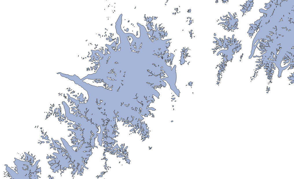
Fig. 4 Example of the glacier complex product (light blue), with outlines in black. In comparison with the glacier product, the divides between individual glaciers have disappeared and the entire ice mass constitutes one single entity.#
Product files#
In the following, file contents are explained using RGI region 01 (Alaska) as example:
RGI2000-v7.0-C-01_alaska.shpThe RGI glacier complex outlines as a shapefile (with accompanying
.dbf,.prj,.cpgand.shxfiles).RGI2000-v7.0-C-01_alaska-attributes.csvGlacier complex attributes in a
.csvfile. The attributes are strictly the same as those encountered in the shapefile. This file allows users to read glacier attributes without reading the entire shapefile.RGI2000-v7.0-C-01_alaska-attributes_metadata.jsonDescription of the attributes in the glacier complex product shapefile: full name, description, units, etc. The content of this file is displayed in Full list of attributes below.
RGI2000-v7.0-C-01_alaska-CtoG_links.jsonLinks between the glacier complex to the glacier products, in a JSON dictionary. The keys are the glacier complex identifiers (same length as the glacier complex file) and the values are the corresponding glacier product identifiers (one or more depending on the size of the cluster).
Full list of attributes#
The following attributes are available in the RGI 7.0 shapefiles.
rgi_idlong_name: RGI identifier
description: Unique identifier assigned to a single glacier complex.
datatype: str
units:
source: RGIo1regionlong_name: First order region
description: The code of the first-order region to which the glacier belongs.
datatype: str
units:
source: RGIo2regionlong_name: Second order region
description: The code of the second-order region to which the glacier belongs.
datatype: str
units:
source: RGIcenlonlong_name: Center longitude
description: Longitude of an approximately central point within the glacier outlines (not the centroid).
datatype: float
units: degrees
source: RGIcenlatlong_name: Center latitude
description: Latitude of an approximately central point within the glacier outlines (not the centroid).
datatype: float
units: degrees
source: RGIutm_zonelong_name: UTM zone
description: Number of the UTM zone for this glacier complex, based on its representative point. Note that this attribute is for information only, the geometries are all in WGS84.
datatype: int
units:
source: RGIarea_km2long_name: Glacier complex area
description: Area of the glacier complex.
datatype: float
units: km2
source: RGIgeometrylong_name: Geometry
description: Glacier complex geometry (Polygon).
datatype:
units: deg
source: RGI