04: Arctic Canada South#
The region encompasses all glaciers in northeast Canada south of 74°N including Baffin Island and Northern Newfoundland.
Subregions
04-01: Bylot Island
04-02: West Baffin Island
04-03: North Baffin Island
04-04: Northeast Baffin Island
04-05: East Central Baffin Island
04-06: South East Baffin Island
04-07: Cumberland Sound
04-08: Frobisher Bay
04-09: Labrador
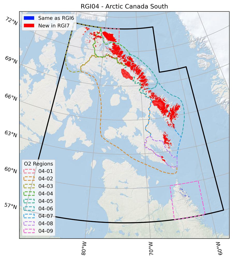
Fig. 21 Regional glacier area. Download high resolution version.#
Changes from version 6.0 to 7.0#
Baffin Island and Bylot Island
The RGI 6.0 glacier outlines were modified using end-of-summer Landsat 7 ETM+ images acquired between 1999 and 2002. Corrections included the addition of missing glaciers or glacier parts (incl. debris cover), removal of seasonal snow and new drainage divides based on a flow direction grid derived from the ArcticDEM at 10 m resolution and the surface flow fields (magnitudes) by Millan et al. [2022]. For the southern part of Baffin Island (incl. parts of Penny Ice Cap) RGI 6.0 outlines were replaced by new outlines based on three Landsat 7 ETM+ scenes. Several small ice patches in the south of Baffin Island were added after visual inspection of the ESRI Basemap.
Additional information#
Data sources and analysts
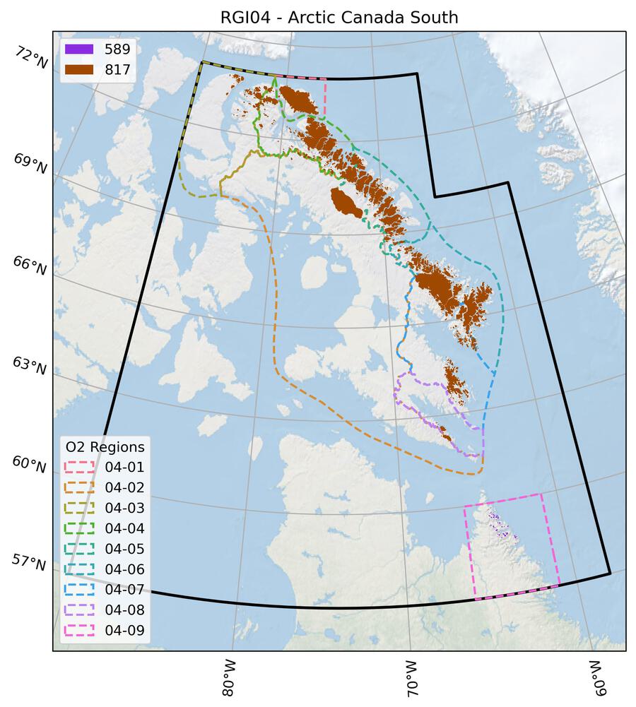
Fig. 22 Submission IDs used for this region Download high resolution version.#
Glacier outline providers to GLIMS
This list includes the providers of the outlines used in the RGI 7.0 as generated automatically from the GLIMS outlines metadata. We acknowledge that the list may be incomplete due to omissions in the GLIMS database.
- Submission 589
Submitter: Bolch, Tobias.
Number of outlines: 103. Area: 19.8km². Release date: 2015-07-15.
Analysts: Barrand, Nick; Burgess, Dave; Cawkwell, Fiona; Copland, Luke; Filbert, Katie; Gardner, Alex; Hartmann, G; OCallaghan, P; Paul, Frank; Sharp, Martin; Wolken, G.; Wyatt, F..- Submission 817
Submitter: Paul, Frank.
Number of outlines: 10906. Area: 40518.3km². Release date: 2023-03-01.
Analysts: Mabileau, Laure; Paul, Frank; Rastner, Philipp.- Reviewers
Kochtitzky, William;
Regional statistics
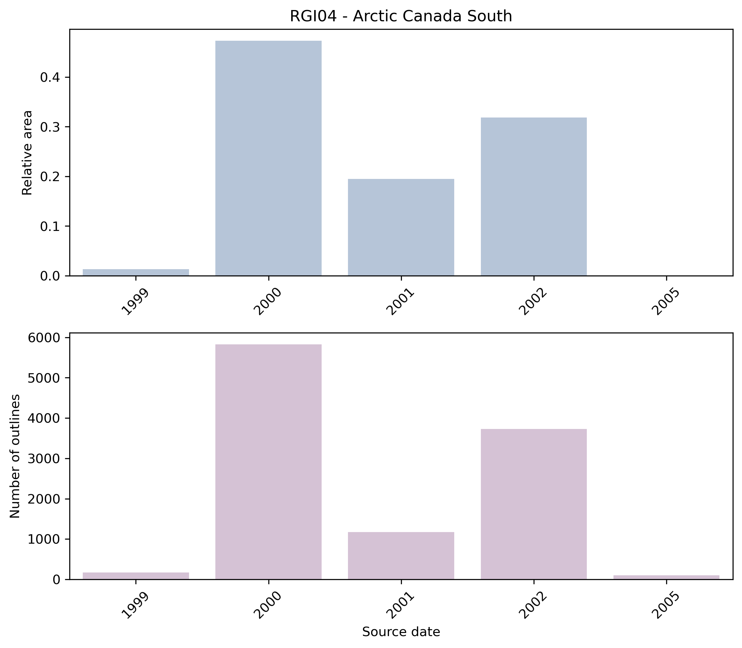
Fig. 23 Distribution of the outline dates per area (top) and number (bottom)#
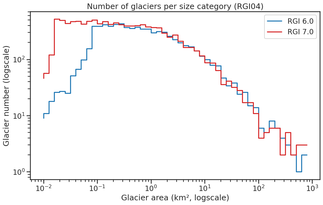
Fig. 24 Number of glaciers per size category (log-log scale).#
Regional number of glaciers (N) and area (km²) per terminus type in RGI 7.0 and RGI 6.0. Note that the default designation in RGI 7.0 is now “Not assigned”, while in RGI 6.0 lake-terminating glaciers and shelf-terminating glaciers were identified in some regions. The RGI region 19 is entirely labelled as “Not assigned” in RGI 7.0.
Value |
Terminus type |
RGI 7.0 (N) |
RGI 6.0 (N) |
RGI 7.0 (Area) |
RGI 6.0 (Area) |
|---|---|---|---|---|---|
0 |
Land-terminating |
0 |
7347 |
0 |
37859 |
1 |
Marine-terminating |
85 |
68 |
3342 |
3030 |
2 |
Lake-terminating |
0 |
0 |
0 |
0 |
3 |
Shelf-terminating |
0 |
0 |
0 |
0 |
9 |
Not assigned |
10924 |
0 |
37196 |
0 |
Regional number of glaciers (N) and area (km²) per surge type attribute in RGI 7.0 and RGI 6.0.
Value |
Surge type |
RGI 7.0 (N) |
RGI 6.0 (N) |
RGI 7.0 (Area) |
RGI 6.0 (Area) |
|---|---|---|---|---|---|
0 |
No evidence |
11002 |
0 |
36536 |
0 |
1 |
Possible |
0 |
0 |
0 |
0 |
2 |
Probable |
6 |
2 |
3776 |
3823 |
3 |
Observed |
1 |
0 |
227 |
0 |
9 |
Not assigned |
0 |
7413 |
0 |
37065 |
Version history
- Changes from Version 5.0 to 6.0
Seven pairs of glacier outlines in east-central Baffin Island were found to have spurious divides that were actually the edges of maps. These pairs were merged: the surviving members of each pair, with the deleted members in parentheses, are RGI60-04.00408 (04.00465); 04.00413 (04.00415); 04.00416 (04.00412) 04.00420 (04.00419); 04.00424 (04.00425); 04.00433 (04.00423); 04.00467 (04.00464).
The source for hypsometry was changed from the ASTER GDEM2 to the ViewfinderPanoramas DEM3 (http://www.viewfinderpanoramas.org/).- Changes from Version 4.0 to 5.0
All glaciers in region 04-09, Labrador, were replaced with information from the inventory of Way et al. [2014].
Links were added to 5 glaciers in the WGMS mass-balance database.- Changes from Version 3.2 to 4.0
Eight exterior GLIMSIds were replaced. Topographic and hypsometric attributes were added.
Glacier 04.06811, which duplicated glacier 04.06813 in version 3.2, was removed.- Changes from Version 3.0 to 3.2
Glaciers were delineated from the glacier complexes using the delineation algorithm developed by Kienholz et al. [2013] and applied to the 1:250000 Canadian Digital Elevation Data (CDED). Some minor manual editing was done to remove obvious blunders.
- Changes from Version 2.0 to 3.0
None.
- Changes from Version 1.0 to Version 2.0
Outlines for 27 glaciers in Labrador (region 04-09) were added, provided by P. O’Callaghan, N. Barrand, F. Wyatt and M. Sharp, University of Alberta.
- Version 1.0
Glacier complex outlines were compiled from 214 CanVec maps, a digital cartographic reference product of Natural Resources Canada. An additional 5500 km2 of glacier area in central Baffin Island not covered by Edition 9 of the CanVec data set were taken from an expanded inventory based on Paul and Kääb [2005] and Svoboda and Paul [2009]. All outlines in this expanded inventory were created from late-summer Landsat 7 ETM+ imagery acquired between 1999 and 2002. Of the CanVec maps, 13 were based on late-summer SPOT 5 imagery acquired between 2006–2010 and seven on 1958 or 1982 aerial photographs. A small fraction of ice coverage is missed by the Canvec dataset because of incorrect classification over debris-covered ice and supraglacial lakes. The misclassification is very noticeable for outlet glaciers where medial moraines are not identified as glacier ice. Glaciers were delineated with the algorithm of Kienholz et al. [2013] and edited manually where necessary.